Kaliningrad Oblast
| Kaliningrad Oblast (English) Калининградская область (Russian) |
|
|---|---|
| - Oblast - | |
.svg.png) |
|
| Coordinates: | |
 Coat of arms |
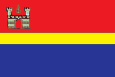 Flag |
| Anthem | None |
| Political status | |
| Country | Russia |
| Political status | Oblast |
| Federal district | Northwestern[1] |
| Economic region | Kaliningrad[2] |
| Administrative center | Kaliningrad[3] |
| Official language | Russian[4] |
| Statistics | |
| Population (2002 Census)[5] | 955,281 inhabitants |
| - Rank within Russia | 57th |
| - Urban[5] | 77.6% |
| - Rural[5] | 22.4% |
| - Density | 63.26 /km2 (163.8 /sq mi)[6] |
| Area (as of the 2002 Census)[7] | 15,100 km2 (5,830.1 sq mi) |
| - Rank within Russia | 76th |
| Established | April 7, 1946 |
| License plates | 39 |
| ISO 3166-2:RU | RU-KGD |
| Time zone | USZ1/USZ1S (UTC+2/+3) |
| Government (as of September 2009) | |
| Governor[8] | Georgy Boos[9] |
| Legislature | Oblast Duma[8] |
| Charter | Charter of Kaliningrad Oblast |
| Official website | |
| http://gov39.ru | |
Kaliningrad Oblast (Russian: Калинингра́дская о́бласть, Kaliningradskaya oblast) is a federal subject of Russia (an oblast) situated on the Baltic coast. It has a population of 955,281 (2002 Census);[5] 871,283 (1989 Census).[10]
The oblast forms the westernmost part of the Russian Federation, but it has no land connection to the rest of Russia. Since its creation it has been an exclave of the Russian SFSR and then the Russian Federation. The fall of the Soviet Union left it isolated from the 'mainland'. It is surrounded by Lithuania, Poland, and the Baltic Sea. Borderless travel to the main part of Russia is only possible by sea and/or air. This political isolation became more pronounced when Lithuania and Poland both became members of the European Union and NATO, and entered the Schengen Zone, which means that the oblast is surrounded by the territories of these organizations as well.
The oblast's largest city and the administrative center is Kaliningrad (formerly known as Königsberg), which has historical significance as both a major city of the historical state of Prussia and the capital of the former German province of East Prussia, partitioned after World War II between the USSR and Poland, and renamed after the Soviet Head of State Mikhail Kalinin.
The territory of the Kaliningrad Oblast coincides with that of the northern part of historical East Prussia, (German: Nord-Ostpreussen), which was a part of Germany until 1945. In that year, it was occupied by the Soviet Union, cleared of its original population, and officially annexed to Russia under the interpretation of the protocols of the Potsdam Conference.
Currently it is one of Russia's best performing regional economies, bolstered by a low manufacturing tax rate, as set by its 'Special economic Zone' [SEZ] status, given by Moscow. As of 2006, one in three televisions in Russia is made in Kaliningrad, and its population is one of few in Russia which has seen recent strong growth.[11]
Contents |
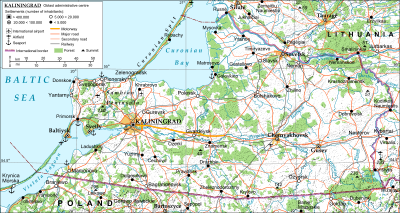
Geography
Kaliningrad Oblast is an exclave of Russia surrounded by Lithuania, Poland, and the Baltic Sea. The biggest river is the Pregolya (Russian: Преголя; German: Pregel; Lithuanian: Prieglius). It starts as a confluence of the Instruch and the Angrapa and drains into the Baltic Sea through Vistula Lagoon. Its length under the name of Pregolya is 123 km (76 mi), 292 km (181 mi), including the Angrapa.
Notable geographical features include:
- Curonian Lagoon (shared with Lithuania)
- Vistula Lagoon (shared with Poland)
Kaliningrad Oblast covers the northern part of the area of former East Prussia, which was an exclave of the Weimar Republic.
Politics
The current governor (since 2005) of Kaliningrad Oblast is Georgy Boos, who succeeded Vladimir Yegorov.
The EU and Russia have had a serious political debate over the oblast territory. The enlargement of the EU in 2004, which saw Poland and Lithuania become member states, meant that the oblast now has land borders only with the EU. Issues of security have been at the forefront of debate, with high relevance to the Schengen Agreement.
After the collapse of the Soviet Union, some intellectuals and government officials in the oblast openly discussed the region separating from Russia. In the mid-1990s, Yuri Matochkin, the oblast's first post-Soviet governor, demanded a special relationship with the EU and threatened a referendum on secession, abetting fears in Moscow about the centrifugal forces of separatism.[12][13] His attempts at elevating the oblast's status to that of a sovereign republic associated with the Russian Federation yielded no results. Around the same time, the secessionist Baltic Republican Party, banned in 2005,[14] aimed at establishing the oblast as the "fourth Baltic state".[13] However, an organized secessionist movement has never emerged there and surveys indicate strong support for remaining a part of Russia.[13]
History
East Prussia
The region of what is now Kaliningrad Oblast was inhabited during the Middle Ages by tribes of Old Prussians in the western part and Lithuanians in the eastern part by the Pregolya and Alna Rivers. The Teutonic Knights conquered the region and established a monastic state. On the foundations of a destroyed Prussian settlement known as Tvanksta, the Order founded the major city of Königsberg (modern Kaliningrad). Germans and Poles resettled the territory and assimilated the indigenous Old Prussians. The Lithuanian-inhabited areas became known as Lithuania Minor. In 1525, Grand Master Albert of Brandenburg secularised the Prussian branch of the Teutonic Order and established himself as the sovereign of the Duchy of Prussia, the Polish fief, later inherited by the Margravate of Brandenburg. The region was reorganized into the Province of East Prussia within the Kingdom of Prussia in 1773.
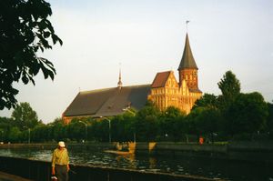
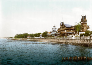
East Prussia was an important center of German culture. Many important figures, such as Immanuel Kant and E. T. A. Hoffmann, have their origins in this region. The cities of Kaliningrad Oblast, despite being heavily damaged during World War II and thereafter, still contain some typical German architecture, such as the Jugendstil, showcasing the rich German history and cultural importance of the area. The Lithuanian-speaking community in East Prussia was diminished due to organic Germanization and cultural assimilation; in the early 20th century Lithuanian still made up a majority only in rural parts of the far northeast corner of East Prussia (Memelland and Minor Lithuania), the rest of the area (with exception of the Slavic Masurians in southern East Prussia), being overwhelmingly German-speaking.
The Memel Territory (Klaipėda region), formerly part of northeastern East Prussia, was annexed by Lithuania in 1923 after World War I. After coming to power in 1933, the Nazi regime in Germany radically altered about a third of the place names (the ones not of German origin) of this area by replacing most names of Old Prussian or Lithuanian origin with newly invented German names in 1938.
Kaliningrad Oblast
During World War II the Soviet Red Army entered the eastern-most tip of East Prussia on August 29, 1944 near Goldap and Nemmersdorf. Evidence of the massacre committed by the Soviet troops in the East Prussian village of Nemmersdorf spread panic in the province and urged a mass flight westward. However, in spite of this, the Nazis kept East Prussia's civil population firmly at home by threat of a death-penalty for 'cowardly deserting'. As evacuation was only allowed at the very last moment, many were unable to escape — overrun by Soviet units or caught at home. They were killed by the Soviet army, as well as by the severe frost.
More than two million people were evacuated, many of them via the Baltic Sea. The remaining population was deported after the war ended and the area was repopulated primarily by the Russians and, to a lesser extent, by the Ukrainians and Belarusians.
The Potsdam Agreement of world powers assigned northern East Prussia to the Soviet Union pending the final determination of territorial questions at the peace settlement:
VI. CITY OF KOENIGSBERG AND THE ADJACENT AREA
The Conference examined a proposal by the Soviet Government that pending the final determination of territorial questions at the peace settlement the section of the western frontier of the Union of Soviet Socialist Republics which is adjacent to the Baltic Sea should pass from a point on the eastern shore of the Bay of Gdansk to the east, north of Braunsberg and Goldap, to the meeting point of the frontiers of Lithuania, the Polish Republic and East Prussia. The Conference has agreed in principle to the proposal of the Soviet Government concerning the ultimate transfer to the Soviet Union of the city of Koenigsberg and the area adjacent to it as described above, subject to expert examination of the actual frontier. The President of the United States and the British Prime Minister have declared that they will support the proposal of the Conference at the forthcoming peace settlement. [2]
In 1957, an agreement was signed and later came into force which delimited the boundary between Poland and the Soviet Union,[15][16]
According to some accounts from the 1950s and 1960s, the Soviet government had planned to make the rest of the area a part of the Lithuanian SSR immediately after World War II. The area was administered by the planning committee of the LSSR, although the area had its own Party committee. However, the leadership of the Lithuanian SSR (especially Antanas Sniečkus) refused to take the territory mainly because of its devastation during the war. Some modern nationalistic Lithuanian authors say that the reason for the refusal was the Lithuanians' concern to find themselves on equal demographic terms with the Russian population within the Lithuanian SSR. Instead the region was added as an exclave to the Russian SFSR, and since 1946 it has been known as Kaliningrad Oblast. According to some historians, Joseph Stalin created it as an oblast separate from the LSSR because it further enclosed the Baltic republics from the West.[17] Names of the cities, towns, rivers, and other geographical objects were changed into newly-created Russian ones.
The collapse of the Soviet Union in 1991 and the independence of the Baltic states caused Kaliningrad Oblast to be separated from the rest of Russia by other countries instead of other Soviet republics. Some ethnic Germans began to return to the area, especially Volga Germans from other parts of Russia and Kazakhstan, especially after Germany stopped granting free right of return to ethnic Germans from the former Soviet Union. The economic situation has been badly affected by the geographic isolation (and the significant reduction in the size of the Russian military garrison which had previously been one of the major employers), especially when neighboring nations imposed strict border controls when they joined the European Union. Russian proposals for visa-free travel between the EU and Kaliningrad have so far been rejected by the EU. Travel arrangements based on the Facilitated Transit Document (FTD) and Facilitated Rail Transit Document (FRTD) have been made.[18][19]
In recent times, the situation has begun to change, if slowly. Germany and Lithuania have renewed contact with Kaliningrad Oblast through town twinning and other projects. This has helped to promote interest in the history and the culture of the East Prussian and Lietuvininkai communities.
Military
For some years after the fall of the Soviet Union, Kaliningrad Oblast was one the most militarized areas of the Russian Federation, and the density of military installations was the highest in Europe, as much of the Soviet equipment pulled out of Eastern Europe was left there. As of 2009, there are 11,600 Russian ground troops based in the oblast, plus additional naval and air force personnel.[20] Thus military troops amount to less than 2% of the oblast's population. Kaliningrad is a headquarters of Russian Baltic Fleet circled by Chernyakhovsk (air base), Donskoye (air base), and Kaliningrad Chkalovsk (naval air base).
The Washington Times claimed on January 3, 2001, citing anonymous intelligence reports, that Russia had transferred tactical nuclear weapons into a military base in Kaliningrad for the first time since the Cold War ended. Russian top-level military leaders denied those claims[21]. A Pentagon spokesperson stated that deployment would violate Russian pledge that Russia was removing nuclear weapons from the Baltics. Russia and the United States announced in 1991 and 1992 a non-binding agreement to reduce arsenals of tactical nuclear weapons. On the eve of the reunification of Germany, Helmut Kohl promised Mikhail Gorbachev that NATO's military infrastructures would not move eastward into the territory of East Germany, a fact since confirmed by the former U.S. Ambassador to Moscow Jack Matlock. Later Russia was privately assured that Eastern European states would not seek membership in NATO[22]. Today, while NATO has not established any military infrastructure in Eastern Germany yet, both Central European and Baltic countries are NATO members.
On November 5, 2008, Russian President Dimitry Medvedev said that Russia would deploy Iskander missiles in the oblast as a response to U.S. plans for basing missile defense missiles in Poland.[23] Equipment to electronically hamper the operation of future U.S. missile facilities in Poland and the Czech Republic also would be deployed, he said.
However, on January 28, 2009, a Russian defense official stated that the deployment of short-range missiles into Kaliningrad Oblast would cease due to perceived changes in the attitude of the United States government towards the Russian Federation following the election of United States President Barack Obama.[24]
Administrative divisions
Demographics
Population
According to the 2002 Census the population of the region was 955,281 (78% urban; 22% rural). Kaliningrad Oblast is the fourth most densely populated in the Russian Federation, with 62.5 persons/km2 (162 persons/sq mi). Almost none of the pre-World War II Lithuanian population (Lietuvininks) or German population remain in Kaliningrad Oblast.
Ethnic groups
According to the 2002 Census, the national composition included:
- 786,885 Russians (82.37%)
- 50,748 Belarusians (5.31%)
- 47,229 Ukrainians (4.94%)
- 13,937 Lithuanians (1.46%)
- 8,415 Armenians (0.88%)
- 8,340 Germans (0.87%)
- 4,729 Tatars (0.50%)
- 3,918 Poles (0.41%)
- 2,959 Azeris (0.30%)
- 2,320 Mordvins (0.24%)
- 2,027 Chuvash (0.21%)
- 1,599 Jews (0.17%)
- 1,447 Roma (0.15%)
- 1,116 Moldovans (0.12%)
- 738 Chechens (0.08%)
- 709 Latvians (0.07%)
- 681 Georgians (0.07%)
- 631 Kazakhs (0.07%)
- 631 Uzbeks (0.07%)
- 562 Bashkirs (0.06%)
- 504 Yezidi (0.05%)
- 448 Mari (0.05%)
- 433 Ossetians (0.05%)
- 382 Udmurts (0.04%)
- 359 Lezgins (0.04%)
- 346 Bulgarians (0.04%)
- 309 Tajiks (0.03%)
- 305 Americans (0.02%),
as well as other groups of less than three hundred persons each. An additional 0.93% of residents declined to state their nationality or ethnocultural identity on the census questionnaire.[25]
Economy
Kaliningrad Oblast's economy is positively influenced by several factors, such as ice-free ports, the world's largest amber deposits and proximity to European countries. The region also has a developed tourist infrastructure, unique museums and monuments, and tourist attractions such as the famous Curonian Spit.[26]
In order to combat the oblast's economic problems such as high unemployment, in 1996 the Russian authorities granted Kaliningrad special economic status and tax advantages intended to attract investors. Oblast's economy has since benefited substantially, and in recent years experienced a boom. A US$45 million airport terminal has been opened, and the European Commission provides funds for business projects under its special program for the region. The oblast has begun to see increasing trade with the countries of the EU as well as increasing economic growth and rising industrial output.[27]
According to official statistics, the Gross Regional Product in 2006 was 115 billion roubles.[28] GRP per capita in 2007 was 155,668.9 rubles.[29]
Industry
The oblast has transport (railcars) and heavy equipment (crane) plants. Car and truck assembly (GM, BMW, Kia, Yuejin), and production of auto parts are growing industries. There are shipbuilding facilities in Kaliningrad and Sovetsk. Food processing is a mature industry in the region. OKB Fakel– a world leader in the field of Hall thruster development and a leading Russian developer and manufacturer of electric propulsion systems is based in Neman. The company employs 960 people.[30][31]
Natural resources
Kaliningrad Oblast possesses more than 90% of the world's amber deposits.[32] Most of the mined amber is processed outside of the region, both in Russia and in other countries.
There are small oil reservoirs beneath the Baltic Sea not far from Kaliningrad's shore. Small-scale offshore exploration started in 2004 and some Baltic countries (Poland and Lithuania), as well as local NGOs voiced concerns regarding possible environmental impact.
Fishing
Fishing is one of the important regional industries, with big fishing ports in Kaliningrad and Pionersky (formerly Neukuhren) and lesser ones in Svetly and Rybachy.
Power generation
Average yearly power consumption in the Kaliningrad Oblast was 3.5Bn kWh in 2004 with local power generation providing just 235M kWh. The balance of energy needs required was imported from neighbouring countries. A new Kaliningrad power station was built in 2005, covering 50% of the oblast's energy needs. A second power station is scheduled to enter service in 2010, making the oblast independent from electricity imports. There are plans to build two nuclear power reactors in the eastern part of Kaliningrad.
References
- ↑ Президент Российской Федерации. Указ №849 от 13 мая 2000 г. «О полномочном представителе Президента Российской Федерации в федеральном округе». Вступил в силу 13 мая 2000 г. Опубликован: "Собрание законодательства РФ", №20, ст. 2112, 15 мая 2000 г. (President of the Russian Federation. Decree #849 of May 13, 2000 On the Plenipotentiary Representative of the President of the Russian Federation in a Federal District. Effective as of May 13, 2000).
- ↑ Госстандарт Российской Федерации. №ОК 024-95 27 декабря 1995 г. «Общероссийский классификатор экономических регионов. 2. Экономические районы», в ред. Изменения №5/2001 ОКЭР. (Gosstandart of the Russian Federation. #OK 024-95 December 27, 1995 Russian Classification of Economic Regions. 2. Economic Regions, as amended by the Amendment #5/2001 OKER. ).
- ↑ http://www.russia-channel.com/kaliningrad-oblast/
- ↑ According to Article 68.1 of the Constitution of Russia, Russian is the official language on the whole territory of the Russian Federation. Article 68.2 further stipulates that only the republics have the right to establish official languages other than Russian.
- ↑ 5.0 5.1 5.2 5.3 Федеральная служба государственной статистики (Federal State Statistics Service) (2004-05-21). "Численность населения России, субъектов Российской Федерации в составе федеральных округов, районов, городских поселений, сельских населённых пунктов – районных центров и сельских населённых пунктов с населением 3 тысячи и более человек (Population of Russia, its federal districts, federal subjects, districts, urban localities, rural localities—administrative centers, and rural localities with population of over 3,000)" (in Russian). Всероссийская перепись населения 2002 года (All-Russia Population Census of 2002). Federal State Statistics Service. http://perepis2002.ru/ct/html/TOM_01_04_1.htm. Retrieved 2010-03-01.
- ↑ The value of density was calculated automatically by dividing the 2002 Census population by the area specified in the infobox. Please note that this value may not be accurate as the area specified in the infobox is not necessarily reported for the same year as the Census (2002).
- ↑ Федеральная служба государственной статистики (Federal State Statistics Service) (2004-05-21). "Территория, число районов, населённых пунктов и сельских администраций по субъектам Российской Федерации (Territory, Number of Districts, Inhabited Localities, and Rural Administration by Federal Subjects of the Russian Federation)" (in Russian). Всероссийская перепись населения 2002 года (All-Russia Population Census of 2002). Federal State Statistics Service. http://perepis2002.ru/ct/html/TOM_01_03.htm. Retrieved 2008-10-17.
- ↑ 8.0 8.1 Charter, Article 3
- ↑ Official website of the Government of Kaliningrad Oblast. Biography of Georgy Valentinovich Boos (Russian)
- ↑ "Всесоюзная перепись населения 1989 г. Численность наличного населения союзных и автономных республик, автономных областей и округов, краёв, областей, районов, городских поселений и сёл-райцентров. (All Union Population Census of 1989. Present population of union and autonomous republics, autonomous oblasts and okrugs, krais, oblasts, districts, urban settlements, and villages serving as district administrative centers.)" (in Russian). Всесоюзная перепись населения 1989 года (All-Union Population Census of 1989). Demoscope Weekly (website of the Institute of Demographics of the State University—Higher School of Economics. 1989. http://demoscope.ru/weekly/ssp/rus89_reg.php. Retrieved 2007-12-13.
- ↑ "Kaliningrad erases stains of past". BBC News. 2006-10-16. http://news.bbc.co.uk/2/low/europe/6048708.stm. Retrieved 2010-05-07.
- ↑ Richard J. Krickus (2002), The Kaliningrad question, pp. 68-69. Rowman & Littlefield, ISBN 0742517055
- ↑ 13.0 13.1 13.2 Maximilian Spinner (2007), Kaliningrad - An Russian Enclave in Central Europe in Search for an Identity, pp. 14-15. GRIN Verlag, ISBN 3638757900
- ↑ Immigration and Refugee Board of Canada, Russia: The Baltic Republican Party in Kaliningrad; mandate, structure, membership and treatment of its members by the authorities; whether the party has ceased its operations and been renamed the Kaliningrad Public Movement-Respublika (2001-May 2005), 10 June 2005. RUS100121.E. Online. UNHCR Refworld, available at: [1]. Retrieved on 10 March 2009
- ↑ http://www.un.org/Depts/los/LEGISLATIONANDTREATIES/PDFFILES/TREATIES/RUS-POL1957SF.PDF
- ↑ http://www.un.org/Depts/los/LEGISLATIONANDTREATIES/STATEFILES/POL.htm
- ↑ Weinberg, Gerhard L. (2005). Visions of Victory: The hopes of eight World War II leaders. Cambridge University Press. p. 114. ISBN 9780521852548. http://books.google.com/?id=0eYhHoIPEm4C&pg=PA114&lpg=PA114&q=.
- ↑ Transit from/to Kaliningrad Region, www.euro.lt
- ↑ Council Regulation (EC) No 693/2003, eur-lex.europa.eu
- ↑ Military Balance 2009
- ↑ Bill Gertz, "Russia Transfers Nuclear Arms to Baltics," Washington Times, 3 January 2001, p. 1.
- ↑ Don't isolate us: a Russian view of NATO expansion
- ↑ "Russia to move missiles to Baltic". bbc.co.uk (BBC). 2008-11-05. http://news.bbc.co.uk/1/hi/world/europe/7710362.stm. Retrieved 12 November 2008.
- ↑ "Russia 'halts missile deployment'". bbc.co.uk (BBC). 2009-01-28. http://news.bbc.co.uk/2/hi/europe/7855216.stm. Retrieved 2009-01-28.
- ↑ (XLS) National Composition of Population for Regions of the Russian Federation. 2002 Russian All-Population Census. 2002. http://www.perepis2002.ru/ct/doc/English/4-2.xls. Retrieved 2006-07-20.
- ↑ "Kaliningrad Region - Introduction". Russia: All Regions Trade & Investment Guide. CTEC Publishing LLC. 2008. http://www.russiasregions.com/north_ossetia_alania.html.
- ↑ "Regions and territories: Kaliningrad". BBC News. 2009-05-15. http://news.bbc.co.uk/2/hi/europe/country_profiles/6177003.stm. Retrieved 2009-06-05.
- ↑ Regional administration's website (Russian)
- ↑ Валовой региональный продукт на душу населения Федеральная служба государственной статистики
- ↑ "EDB Fakel". OKB Fakel. http://users.gazinter.net/fakel/index_eng.html. Retrieved 2009-06-04.
- ↑ "OKB Fakel (Russian Federation)". Jane's Space Systems and Industry. 2008-12-17. http://www.janes.com/articles/Janes-Space-Systems-and-Industry/OKB-Fakel-Russian-Federation.html. Retrieved 2009-06-04.
- ↑ How Products Are Made: Amber
- Simon Grunau, Preußische Chronik. Hrsg. von M. Perlbach etc., Leipzig, 1875.
- A. Bezzenberger, Geographie von Preußen, Gotha, 1959
- Областная Дума Калининградской области. Закон №30 от 18 января 1996 г. «О вступлении в действие Устава (Основного Закона) Калининградской области», в ред. Закона №650 от 29 сентября 2005 г. «О внесении изменений и дополнений в Устав (Основной Закон) Калининградской области». Вступил в силу по истечении десяти дней со дня официального публикования, за исключением пункта 5 статьи 15 и подпункта "б" статьи 22 в части подписания постановлений областной Думы председателем областной Думы, которые введены в действие одновременно со вступлением в силу Федерального закона от 06.10.1999 №184-ФЗ "Об общих принципах организации законодательных (представительных) и исполнительных органов государственной власти субъектов Российской Федерации. Опубликован: "Янтарный край", №20, 26 января 1996 г. (Oblast Duma of Kaliningrad Oblast. Law #30 of January 18, 1996 On the Charter (Basic Law) of Kaliningrad Oblast Taking Effect, as amended by the Law #650 of September 29, 2005 On Amending and Supplementing the Charter (Basic Law) of Kaliningrad Oblast. Effective as of the date ten days after the official publication date, with the exception of item 5 of Article 15 and the portion of subitem "b" of Article 22 dealing with the signing of the resolutions of the Oblast Duma by the Chair of the Oblast Duma, which take effect simultaneously with the Federal Law #184-FZ of October 6, 1999 "On the General Principles of the Organization of the Legislative (Representative) and Executive Organs of the State Power in the Federal Subjects of the Russian Federation).
External links
- Official website of Kaliningrad Oblast (Russian)
- A. Liucija Arbusauskaité "The Soviet Policy Towards the "Kaliningrad Germans" 1945-1951" chapter in "Themenheft: Eingliederung und Ausgrenzung. Beiträge aus der Historischen Migrationsforschung. Hrsg.: Jochen Oltmer Osnabrück: IMIS, 1999. ISSN 0949-4723
- Photos of Kaliningrad
- Photos of Kaliningrad Oblast by Dutch Joost Lemmens
- Master's thesis by Sergey Naumkin on the possibility of Kaliningrad integrating with the EU as a special economic zone
- Life in Kaliningrad Oblast (Russian)
- Spuren der Vergangenheit / Следы Пρошлого (Traces of the past) This site by W.A. Milowskij, a Kaliningrad resident, contains hundreds of interesting photos, often with text explanations, of architectural and infrastructural artifacts of the territory's long German past. (German) (Russian)
- City and Reagen News